| |

| The Start |
| This journey will start at Land's End at approximately 9am on Saturday morning. |
| Itinerary |
View a quick list of all the photos found on this page. |
| June 7th |
Land's End to St Columb Major |
55 miles |
|
From the tourist complex as Land's End we follow the spectacular north coast of Cornwall, through pretty coastal valliages and sandy beaches before turning inland to the small town of St Colomb Major.
|
|
Postcard from St Columb Major
Day 1 - Lands End to St Columb Major
The cyclists (all 18 of us) met at the Lands End signpost & had our photo taken together. It was a great day to start off, along the north Cornish coast, with the weather being hot and sunny. The days ride lasted from 10am to 6pm. The journey was broken up into two parts: a 3hr 25min morning ride with 3hr 15min one in the afternoon. The only incidents were my chain coming off and being chased by a dog. In the afternoon I had to walk up a few steep hills, whilst James (Steves eldest son) was not phased by them at all. It did mean he had opportunity to check the route ahead while he waited at the top of the hill for me! Steve shadowed our 1st day in the van in which he had brought us to Lands End
I suspect just in case we were ready to go home at the end of it!! Being a cyclist in his youth, although you wouldnt think it to look at him now, I think Steve knew more about what we had let ourselves in for!! We arrived at St. Columb Major quite exhausted and a little sun burned, the first day now over it was time for a well earned rest. The B&B where James & I stayed was very welcoming. The host kindly drove us to the pub where all the cyclists met up for dinner & saved us a hike up a hill. The hostess also generously sponsored me on my trip. B&B: Greenbank, St Mawgan, Cornwall, TR8 4EW
Todays route: Lands End - St Just - Morvah - Zennor - Hayle - Gwithian - Portreath (lunch) - Bridge - Porthtowan - St Agnes - Trevellas - Perranporth - St Newlyn East - St Columb Major (Trekenning Tourist Park)
Days Total Distance: 58.2 miles
Journeys Total Distance: 58.2 miles
Counties travelled through today: Cornwall
Photos: -
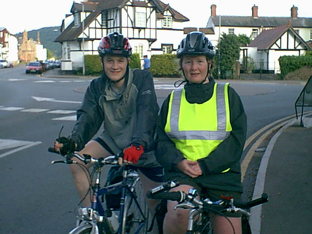
 James at Land's End signpost James at Land's End signpost
Rosie at Land's End signpost
Rosie & James at Land's End
My trusty steed!
The cyclists
|
|
| June 8th |
St Colomb Major to Whiddon Down |
60 miles |
|
A tough day that takes us around the southern edge of Bodmin Moor and through the highest village in Cornwall. We then continye through Tavistock and across the wild moors of Dartmoor National Park.
|
|
Postcard from Princetown
Day 2 - St Columb Major to Princetown
Todays effort started off from St Columb Major at 9:15am and finished arriving at Princetown (a change from the original itinerary) at 6:15pm with a total distance covered of 51.8 miles. The morning ride was 3hrs of pouring rain while the afternoon was dry but cloudy. James chain caught in his chain guard & he was helped by Peter & Richard The Somerset Boys. We lunched at the Minions, the highest point in Cornwall. With lots of steep hills today some footwork was required even for those that managed ok the previous day. On the upside (or should that be downside!), with a weight advantage, I got to the bottom of the hills faster than the other cyclists. We crossed the Cornwall border today and are now in Devon staying overnight in Dartmoor Forest. Legs were being to feel sore. I had trained for cycling, not for walking up hills!! We stayed at The Railway Inn where the food was very good & we managed to hand wash some clothes
Todays route: St Columb Major - Bodmin - Mount - St Neot - Minions (lunch) - Upton Cross - Rilla Mill - Bray Shop - Horsebridge - Tavistock - Princetown (Plume of Feathers)
Days Total Distance: 51.8 miles
Journeys Total Distance: 110 miles
Counties travelled through today: Cornwall & Devon
Photos: -
Colin & James leaving Cornwall
Rosie cycling out of Cornwall - 1 county done!
Enos, James, Alan, Rosie & Colin make it to Devon
|
|
| June 9th |
Whiddon Down to Bridgewater |
60 miles |
|
We continue following narrow hilly lanes through the beautiful countryside of Devon before crossing into Somerset, with final climb that tkaes us over the Quantock Hills and down to Bridgewater.
|
|
Postcard from Bridgwater
Day 3 - Princetown to Bridgewater
Today we had a long time on the bike. Starting at 9am and cycling through till 3pm, stopping for lunch at Tiverton, then off again at 4pm. Eventually reaching Bridgwater at 8pm, cycling the last hour and a half in the rain. A total distance covered today of 80.5 miles crossing over from Devon to Somerset. Each day on the journey there was an experienced cyclist who acted as the mechanic & back marker. For the 1st part of the trip it was Ray Bennett. Today Ray waited patiently, in the rain, as Colin & I climbed the Quantock Hills!! Managed to trigger the speed sign indicator entering a village and seeing the speed flash up (24.6mph & 21mph) in a 20mph zone! I was yet again chased by a dog, must be my perfume! We waited at the Campsite for the support van to take us to our B&B, however by the time it arrived it was almost 9pm so Kevin decided we should try & get somewhere to eat. Unfortunately that involved driving around the one-way system in Bridgwater trying to find somewhere that was still serving food. Eventually arrived at a Chinese at 9.40pm. It was too late for James & I so we opted to go to our B&B instead. I finally got a shower & began to warm up at 10.45pm, couldnt get to sleep though until after 1am. Our hostess at the B&B sponsored both James & I, I think she felt sorry for the tired & drowned rats!!
Todays route: Princetown - Two Bridges - Postbridge - Widdon Down - Hittisleigh - Yeoford - Crediton - East Village - Poughill - Tiverton (lunch) - Uplowman - Holcombe Rogus - Langford Budville - Milverton - Halse - Bishops Lydeard - Enmore - Durleigh - Bridgwater - Bawdrip - Fairways International Caravan & Camping Park
Days Total Distance: 80.5 miles
Journeys Total Distance: 190.5 miles
Counties travelled through today: Devon & Somerset |
|
| June 10th |
Bridgwater to Monmouth |
75 miles |
|
An easy day as we cross the flat Somerset Levels to Cheddar, from where we cross the Mendip Hills through the famous Gorge and continue on to the the outskirts of Bristol. We cross the River Avon on a local cycle path, and then continue around Bristol on local lanes and cycle paths, before crossing the Severn Bridge and heading into Wales.
|
|
Postcard from Monmouth
Day 4 - Bridgwater to Monmouth
A 9:10am start off from Bridgwater. Nice & flat along the Somerset levels. James & I made good time & for once made the elevens stop which today was at Cheddar Gorge. During the break I managed to twist my ankle. The morning run was 39.2 miles. For lunch (2-3pm) we met up with my Mum and Dad, lunch was at the services as the pub had stopped serving at 2pm. We spent some of the afternoon on the Avon Cycleway. We crossed the Bristol Channel on the old Severn Bridge and reached Monmouth at 7:40pm. Alan suffered two punctures, which Ray dealt with. In addition to the ankle all my leg muscles are now hurting with saddle sore starting to kick in and there's still a long way to go! Mum & Dad met us again in Monmouth & treated us to a super meal at Bobs. Mum also did our hand washing. Thanks Mum! Got to bed about 11.30pm. Encouraging text message from Steve I think you both doing very well & Im very proud. Goodnight, sweet dreams
Todays route: Woolavington - Blackford - Cheddar - Regil - Winford - Failand - Portbury - Easton-in-Gordano (lunch) - Pill - Hallen - Easter Compton - Olveston - St Arvans - Parkhouse - Trelleck - Monmouth - Monmouth Caravan Park
Days Total Distance: 76.2 miles
Journeys Total Distance: 266.7 miles
Counties travelled through today: Somerset, North Somerset, Bristol, South Gloucestershire, Gloucestershire & Monmouthshire
Photos: -
James cycling up Cheddar Gorge, I only stopped to take the photo!
Rosie & James
John O'Groats or Bust |
|
| June 11th |
Monmouth to Little Stretton |
70 miles |
|
From Monmouth our route takes us north across the River Wye and through the pretty rolling countryside of Herefordshire and into Shropshire to the base of the Lorn Myndd.
|
|
Postcard from Wentnor
Day 5 - Monmouth to Wentnor
The days cycle started, at 9.20am, with the weather cloudy. There was some hard terrain coming out of Monmouth (morning dist. 29 miles). A fellow cyclist missed todays ride due to blisters and was taken in van. He was further disadvantaged as he had left his cycling shoes at his B&B in Monmouth! Kevin, the trip organiser, drives the support van & transports the luggage between campsites & B&Bs whilst we cycle. The terrain and weather improved as the day progressed, becoming more like my expectations of how the trip would be. The afternoon cycle was hit with some delays: Niels chain broke but was fixed by Ross (our new mechanic & back marker) and I fell off my bike. On a sharp downhill turn I slid on some mud causing my bike to go one way and myself the other. I got off lightly with cuts & bruises. It will take more than that to stop me!! Colin who saw the whole thing, being immediately behind me, said it was elegantly done; I think he was just being gallant! We reached Wentnor at 6:40pm. James' mum, Lyn, met us in the evening & treated James & I to dinner.
Todays route: Monmouth - Rockfield - Maypole - Skenfrith - Bagwyllydiart - Wormbridge - Kingstone - Tyberton - Moccas (drinks & snacks) - Bredwardine - Staunton on Wye - Weobley - Luntley - Pembridge - Staunton on Arrow - Lingen - Birtley - Brampton Bryan - Bucknell - Bedstone - Hopton Castle - Twitchen - Purslow - Wentnor - The Green Camping & Caravan Park
Days Total Distance: 71.65 miles
Journeys Total Distance: 338.35 miles
Counties travelled through today: Monmouthshire, Herefordshire & Shropshire
Photos: -
Waiting for the traffic jam to clear!
Rosie, Colin & James
|
|
| June 12th |
Little Stretton to Acton Bridge |
70 miles |
|
We continue north through Shropshire countryside on some lovely roads. The route skirts around Shrewsbury, passing close to the Welsh border as we head into Cheshire and through the Delaware forest.
|
|
Postcard from Acton Bridge
Day 6 - Wentnor to Acton Bridge
Up at 7am this morning for a huge breakfast after which we started off at 9:15am. Today I was sore after yesterdays fall; it was tough going on the knees although fortunately there was plenty of flat terrain. Despite being a bit slower today it seemed we passed more of the cyclists on route - not sure if I'm getting faster or they are getting tired! We crossed over the Shropshire Union Canal. We stopped at Malpas at 1:55pm for a pub lunch, 42.4miles for the morning. The afternoon was a shorter ride lasting from 3:15pm to 5:50pm finishing at Acton Bridge.
Some info about our merry band of cyclists: 18 cyclists (3 women & 15 men) James is the youngest at 15, Gavin the oldest at 70. The average age being 54, so its not too late if you would like to consider it
! Gavin commented that this route is harder than any he has taken & hes done some amazing trips; two of which were across America (4,500 miles and 3,000 miles). Some of our group are raising money for charity Jane and Gordon (Cancer Research UK), Jill (local hospice), James (NSPCC & Sheffield Spinal Research Unit) & Richard & Peter & of course myself (local hospice). Some are doing it for the fun of it!! Alan travelled all the way from New York, USA to make the trip. Dave, Enos & Edwin have all done the LE2JOG before. Enos made the journey on a 10-day trip. Edwin did the exact same route last year, but had such bad weather he came back again hoping the weather would be better.
Todays route: Wentnor - Habberley - Pontesbury - Montford Bridge - Bomere Heath - Northwood - Bettisfield - Malpas (lunch) - Tarporley - Utkinton - Crowton - Acton Bridge - Woodbine Cottage Caravan Park
Days Total Distance: 69.3 miles
Journeys Total Distance: 407.65 miles
Counties travelled through today: Shropshire, Wrexham & Cheshire
Photos: -
Rosie & James leaving Cheshire
|
|
| June 13th |
Acton Bridge to Clitheroe |
65 miles |
|
We cross the Manchester Ship Canal as we pass between Liverpool and Manchester, ewaving our way through the northern industrial heartland of Englad. Our route takes us across Winter Hill and around Blackburn to Clitheroe.
|
|
Postcard from Clitheroe
Day 7 - Acton Bridge to Clitheroe
Friday the 13th! All started off well at 9:20 leaving Acton Bridge until my sunglasses fell off & broke. James, Colin & I cycled approximately 22 miles and stopped for elevenses at a garden centre with an excellent selection of cakes! Then after just an hour more of our journey the gears on my bike broke. Fortunately the support van was not too far behind. Colin, James & Ross patiently & cheerfully waited for me in a lay-by & had a cuppa even though they could have gone on, whilst Kevin & I went off in the van in search of a cycle shop and a new gearshift. In all we were delayed two hours, but Kevin & Ross fixed my gears & we were off again but we had missed our lunch opportunity. We finally reached our destination at 8:15pm. We got a taxi from the campsite to a hotel where Kevin had arranged for us to be served a meal at 9pm. We stayed at a guest house belonging to Sally & Peter Hatch, who were very friendly, Brooklyn Pimlico Road, Clitheroe, BB7 2AH. Text message from Mary You can do it, go for it!
Todays route: Acton Bridge - Little Leigh - Comberbach - Great Budworth - High Legh - Broomedge - Warburton -
Hollins Green - Glazebrook - Glazebury (Elevenses) - Leigh - Hindley - Aspull - Haigh - Blackrod - Rivington - Belmont - Tockholes - Pleasington - Blackburn - Clayton-Le-Dale - Hurst Green - Clitheroe - Camping & Caravanning Club
Days Total Distance: 66.4 miles
Journeys Total Distance: 474.05 miles
Counties travelled through today: Cheshire, Warrington, Manchester, Blackburn with Darwen & Lancashire |
|
| June 14th |
Clitheroe to Kirkby Stephen |
55 miles |
|
Leaving the industrial are behind we have a fabulous ride that takes us across the open moorland of the Forest of Bowland and then through the beautiful scenery of the Yorkshire Dales National Park.
|
|
Postcard from Kirkby Stephen
Day 8 - Clitheroe to Kirkby Stephen
James & I had an early start at 8:45am, but sadly Dave & Niels had bike trouble & didnt get on route until 1pm (broken wheel rim, I think). Travelling through North Yorkshire and into Cumbria was a very hilly region causing some discomfort on the knees. Those of us who had set off early had a slight detour (2miles) due to a road traffic accident at Slaidburn, involving a motorbike & car. Later that night I found out some of the other cyclists had thought it might have been me with my great speeds downhill! Incidently just before Slaidburn I hit a top speed of 43.7mph.
However there were several steep descents on the way to Dent, which reduced all our brake pads. I arrived in Dent for lunch at 2.45pm where I was joined by Steve and Jake (Steves other son). Afterwards they went on to the campsite to meet James who had gone on ahead to get a fast time. I had more gear problems; I couldn't use my top gears but it didn't matter too much considering the terrain. We conquered the toughest uphill climb so far, passing Dent Station, being 1,750ft and arrived in Kirkby Stephen at 6:30pm. My Aunt Betty and Uncle John, who are considering doing the trip in the future, joined us for dinner.
The Team:
Peter Appleton - Ilminster, Somerset
Richard Carbin - Ilminster, Somerset
Gordon and Jane Barnes - Hadstock, Cambridgeshire
Alastair Bell - Orpington, Kent
Jill Dyer - Notingham
Gavin Goulson - Newport, Shropshire
Malcolm Haigh - Billericay, Essex
Neils Hansen - London
Jim Hind - Doncaster
Rosie McLaughlin - Northampton
James Till - Derby
Dave Raine - Glossop, Derbyshire
Alan Sobel - New York, USA
Enos Turnbull - Malvern, Worcs
James Urquhart - Bottisham, Cambridge
Edwin Whitaker - Chorleywood, Herts
Colin Whitby - Cheltenham, Glos
Tour Leader - Kevin White
Bike Support - Ross Kavanagh & Ray Bennett
Todays route: Clitheroe - Waddington - Newton - Slaidburn - High Bentham - Inlegton - Thornton in Lonsdale - Dent - Cowgill - Nateby - Kirby Stephen - Pennine View Caravan Park
Days Total Distance: 57.57 miles
Journeys Total Distance: 531.62 miles
Counties travelled through today: Lancashire, North Yorkshire & Cumbria
Photos: -
Lonely road into North Yorkshire
|
|
| June 15th |
Kirkby Stephen to Longtown |
65 miles |
|
From Kirby Stephen we head to Appleby-in-Westmoreland and then continue north along the beautiful Eden Valley before crossing Hadrian's Wall into Scotland.
|
|
Postcard from Langholm (Scotland)
Day 9 - Kirkby Stephen to Langholm
The day was sunny and although the wind was against us, the terrain was not difficult to ride. We started at 9.15am. James & I stopped at Glassonby for drinks & snacks. We stopped for lunch at 1.50pm- 3.05pm having done 44.45 miles. As my knees were somewhat improved during the morning ride; I had more power going uphill & speed generally. Ross was quite surprised to have only caught up with us as we lunched. He was not the only one as Steve called us at 3.30pm assuming we would just be arriving at lunch!! We passed Carlisle Airport & saw some of the historical aircraft there. We reached the Scottish border at 4.45pm. Unfortunately my knees began to play up again with 10 miles to go. We arrived at the campsite at 6pm. Kevin had kindly got me Apricot flapjacks as he had noticed I was not eating any of the cakes etc
he laid on each night at the campsite (due to my wheat allergy). Text message from Karen Youre doing great. Keep going. Thinking of you
Todays route: Kirkby Stephen - Soulby - Burrells - Appleby-in-Westmoreland - Long Marton - Newbiggin - Culgaith - Langwathby - Little Salkeld - Glassonby - Kirkoswald - Ainstable - Heads Nook - Corby Hill (lunch) - Laversdale - Hethersgill - Harelaw - Claygate - Langholm - Ewes Water Caravan & Camping Park
Days Total Distance: 70 miles
Journeys Total Distance: 601.62 miles
Counties travelled through today: Cumbria & Dumfries & Galloway
Photos: -
Rosie & James make it to Scotland - half way!
Ross in Scotland (Mechanic & Back marker)
Route profiles by Ross.
|
|
| June 16th |
Longtown to Biggar |
65 miles |
|
We head through the Southern Uplands on some wonderful quietscenic roads. Our route takes us through Moffat and over the Lowther Hills to Biggar.
|
|
Postcard from Biggar
Day 10 - Langholm to Biggar
Started off at 9:05am from Langholm, we stopped for lunch at 11:55am after 29.55 miles. Jill's mudguard split, which was taken off at Moffat. Back on the bike again at 1:30pm, after writing a few postcards, to do a 7mile hill climb. The climb although long was not too challenging. Our host at Lands End had been warned us that the West Country road builders had gone up & down the hills, whereas in Scotland, they built around them. His words proved true. We had also begun to realise a trend that wherever Kevin suggested we stop for lunch was followed by a hill climb!! The weather was brilliant all day, the sun shining. We reached Biggar at our earliest time so far of 4:30pm. My cousin Dee, her husband Johnny & son Andrew joined us for a drink in the evening.
She also kindly brought for me two sets of lotion & soap, which was renowned for keeping away the midges (& so avoid being bitten to death) I gave one of the sets to the campers as their need was greater, the midges particularly liked Jill!
It proved very popular, although the guys said they would have some strange looks from their wives when they got home & asked for the nearest Avon rep!!
Todays route: Langholm - Corrie Common - Boreland - Moffat (lunch) - Broughton - Biggar Caravan & Leisure Park
Days Total Distance: 58.59 miles
Journeys Total Distance: 660.21 miles
Counties travelled through today: Dumfries & Galloway, Scottish Borders & South Lanarkshire
Photos: -
Snacktime for Colin & Alistair
Colin, Rosie & Alistair at the Scottish Borders
Welcome sight, the campsite after a hard day's cycling
|
|
| June 17th |
Biggar to Balloch |
70 miles |
|
Continuing north we leave the quiet countryside behind and continue through to Scotland's largest city, Glasgow. Using mainly local cycle paths we head through the centre of the city and across the River Clyde, ending the day at Balloch on the shore of Loch Lomond.
|
|
Postcard from Balloch
Day 11 - Biggar to Balloch
Started off at 8:35am from Biggar, the weather was cloudy and the wind was against us all morning. When we got to Glassford (where Niels chain broke for the second time) the rain began to pelt down. Niels & Dave took shelter in a phone box whilst Alistair & I (& our bikes!) sought refuge in a bus stop. We stopped for lunch (1:10pm-2.25pm) at a pub, where we found the fastest of the cyclists having their meals completely oblivious to the downpour until we showed up drenched.
The remainder of the days route was mostly on cycle paths. In the afternoon we followed the river Clyde & then the Forth & Clyde canal. The route had been designed to avoid main roads but it was only today that Kevins instructions directed us across a field!! The weather cleared in the evening & Alistair & I arrived in Balloch at 6.45pm
Todays route: Biggar - Thankerton - Carmichael -
Lesmahagow - Boghead - Stonehouse - Glassford - High Blantyre (lunch) - Westburn - Glasgow - Clydebank - Dumbarton - Balloch - Lomond Woods Holiday Park
Days Total Distance: 72.58 miles
Journeys Total Distance: 732.79 miles
Counties travelled through today: South Lanarkshire, Glasgow & West Dumbartonshire |
|
| June 18th |
Balloch to Taynuilt |
70 miles |
|
We have some spectacular scenery as we leave Loch Lomond and head west for a while before turning north to follow the shore of Loch Long to the historic little town of Inveraray. We then continue through Glen Aray and around the head of Loch Awe.
|
|
Postcard from Taynuilt
Day 12 - Balloch to Taynuilt
It was wet and windy all day with a strong head wind and I discovered that my coat isn't waterproof so I got completely soaked through. For once my knees were good and I could use my muscles instead of my gears for a change! So much so that I caught up and overtook the fast four (Malcolm, Jamie, Enos and Jill). We saw HMS Ark Royal docked as we cycled along Loch Long. We climbed up to Rest & Be Thankful Pass, we were thankful the climb had finished but did not rest in the rain!
We stopped for lunch after 36.53 miles at Cairndow in a pub (1pm-2pm) and then continued around Lock Fyne & Loch Awe, passing the Cruachan Power Station. I finished up in Taynuilt at 5pm among the first to arrive for a change!. My knees had given up again about 10 miles from the campsite, not surprising really given the terrain & the headwind. It was good to know there was hot bath to warm up in; it had rained all day bar the last hour. After dinner we all chatted in the bar until quite late. I introduced a few of the guys to a BMW (Baileys Malibu and Whiskey), which Niels took a fancy to.
Bike problems of the day were Niels brakes, both Jamie and Jane had punctures and Richard's tyre split.
Todays route: Balloch - Garelochhead - Arrochar - Cairndow (lunch) - Inveraray - Lochawe - Taynuilt - Crunachy Caravan & Camping Park
Days Total Distance: 69.61 miles
Journeys Total Distance: 802.4 miles
Counties travelled through today: West Dumbartonshire & Argyll & Bute
Photos: -
Gorgeous view of a Loch
|
|
| June 19th |
Taynuilt to Gairlochy |
60 miles |
|
The impressive scenery continues north along the shore of Loch Linnhe to Fort William at the foot of Ben Nevis, the highest peak in the British Isles. From here we follow River Lochy along the Great Glen.
|
|
Postcard from Gairlochy
Day 13 - Taynuilt to Gairlochy
It was not pleasant putting on trainers still soggy from the day before. The improvement of my knees the day before gave me a false confidence & I dawdled a little. Instead of my usual tact of getting away early & seeing everyone pass me through the day I left last with James, Niels & Dave. We set off at 9:15am into a headwind and rises in the road. My sore knees meant the other 3 cyclists were well ahead of me after just six miles. I travelled most of the day on my own, cycling alongside parts of Loch Etive & Loch Creran.
The weather wasn't much of an improvement on the day before being cold and cloudy with a few showers. One particularly heavy shower soaked me again. I crossed into the Highlands at 12 noon & attempted to take a photo of my self on the border (which didnt work!). Kevin, in the van, caught up with me just outside the Holly Tree restaurant at 1pm. Gavin & Jim were inside & Gavin popped out to tell me I could get a nice cuppa inside, so I did.
Ross, mechanic & back marker, caught up with me on the way to Fort William, by now we had a tail wind & were making good progress along loch Linnhe. Saw Gavin & Jim, Alan, Edwin, Dave & Niels & the bikes of some of the others as I passed through Fort William. They took advantage of the shops there to stock up & to look around. Unfortunately due to the cloud we could not see much of Ben Nevis. As I cycled along the B8004 to Gairlochy several fighter planes flew overhead, shattering the peace. I reached Gairlochy at 3:10pm. James had been the first to reach the campsite at 2.30pm. A few of us beat the van today, so there were no tea & cakes waiting for us! James, Colin & I stayed at the same B&B. I took some photos of us having our evening meal. Colin introduced us to Stags Breath (whiskey blended with honey)
Todays route: Taynuilt - Connel - Benderloch - Barcaldine -
Appin Village - Duror - (tea break) - Ballachulish - Fort William - Gairlochy - Gairlochy Holiday Park
Days Total Distance: 60.71 miles
Journeys Total Distance: 863.11 miles
Counties travelled through today: Argyll & Bute & Highland
Photos: -
Enos, Alan, Jim, Jamie & Ross
Malcolm, Alistair & Gavin
Richard, Peter, Edwin, Jane & Gordon
James, Kevin, Colin, Niels & Dave
|
|
| June 20th |
Gairlochy to Evanton |
70 miles |
|
We continue along the Great Glen. There is a choise of a forested cycle path or the road along the shore of Loch Lochy, and then we follow the Caledonian Canal to Fort Augustus. From here we head along the shore of the famous Loch Ness to Drumnadrochit, where we leave the lake and then head through the hills to the shore of Crothmarty Firth.
|
|
Postcard from Evanton
Day 14 - Gairlochy to Evanton
Today started with everyone having sterilised water bottles courtesy of Colin who had given us all sterilising tablets the night before as some folks had mould in their bottles!
We had a choice of two routes: either the main road or the cycle path, the main road would be faster but there would be the traffic to deal with. Colin and I decided to go the cycle path route & started off at 9:15am riding the Great Glen cycle route through the woods along Loch Lochy to Laggan. It was very cold and windy with a few showers in the morning ride.
Shortly after Invergarry we stopped for ½ hour at the Thistle Stop Cafe briefly seeing Gavin & Jim who were leaving as we arrived. We then cycled to Fort Augustus & along the shore of Loch Ness. The support van caught up with us there. We no longer had a mechanic/back marker as Ross had left us this morning due to other previous commitments. So Colin & I volunteered to take up the back marker position! Colin told folk that we had to have a handicap & were made to walk up the hills so we would not beat everyone!!!
We passed Urquhart Castle (Jamies family seat perhaps) then stopped for a break at a garage before tackling the 16% climb to Beauly, naturally Colin & I walked some of it.
On the way into Dingwall Colin decided to go off route on a cycle path & he disappeared, I had visions of him heading miles off route. I thought I would get a break waiting for him to catch up. However fortunately for him although the cycle path was out of sight it did continue parallel to the road I was on & we met up again. We stopped briefly in Dingwall & l bought lucky dips lotto tickets for everyone for tomorrow night. It would be nice if someone won it to finish off the trip! Also in Dingwall I saw a sign "To the North" on it, it tickled me to think we'd cycled 930 odd miles still had yet to reach the north!! Finally we arrived last at Evanton at 6.30pm, Kevin was just about to come & look for us. I was glad the ride was over as I hadn't felt well all day.
Other news of the day: Richard had two punctures. One of the cyclists travelled in the van today due to injury. The fast four, now with James (to become the fast five) took a 7 mile detour to visit a relative of Enos who provided them with beans on toast which is their staple lunch time meal.
Todays route: Gairlochy - Clunes - Invergarry - Fort Augustus - Invermoriston - Drumnadrochit - Beauly - Muir of Ord - Conon Bridge - Dingwall - Evanton - Black Rock Caravan & Camping Park
Days Total Distance: 72.6 miles
Journeys Total Distance: 935.71 miles
Counties travelled through today: Highland (Easter Ross)
Photos: -
Tired & blurry at Ross & Cromaty!
Colin reaches Ross & Cromarty
|
|
| June 21st |
Evanton to Betty Hill |
75 miles |
|
Our longest day of riding takes us through the wild countryside of Northern Scotland. We head across the hills to Bonar Bridge and then continue on some wonderful wild and lonely roads that take us through bleak open moorlands and eventually lead us to the small settlement of Betty Hill on Scotland's north coast.
|
|
Postcard from Bettyhill
Day 15 - Evanton to Bettyhill
The penultimate day started at 9:10am with most of us setting off together although Colin & I soon had the road to ourselves! We stopped at 11:30am for ½ an hour at Rosie's café in Ardgay, once more seeing Gavin & Jim departing as we arrived. We then climbed up to a viewpoint on Struie Hill (660ft) where we took some photos & had a snack (although the penultimate day Colin still had loads of snack bars left!) The day was cloudy & cold, with a head wind, which was quite bracing on the open moorland from Lairg. I called my mum whilst in Lairg for advice on which additional painkillers I could take as my knees were really giving me grief. It's a good job this isn't the Tour de France as for sure I would have failed a drugs test!!
We stopped at 3.30pm - 4.30pm (lunch?!) at the Crask Inn (45.1 miles) which was one of the few buildings we saw on the A836 a 30 mile single track road with passing places! As we were leaving we met another guy who was cycling Lands End to John OGroats on his own. Having done the trip with company I did not envy him.
At the 55mile point Steve overtook us in the van, which was a welcome surprise, as we werent expecting him until tomorrow!! Steve took an action photo of Colin & I arriving at Syre. Kevin came in the van to look for us in case we may have had some problems, however he was reassured we were fine, if a little slower than normal. We continued on our way to Bettyhill. Arriving at 7.35pm we received a rousing round of applause when we got there, everyone else was in the middle of dinner!
Jamie and Alan both suffered punctures today. Everyone was in good spirits, despite not winning the Lotto! I dont think we can quite believe it is the final day tomorrow.
Todays route: Evanton - Ardross - Ardgay - Bonar Bridge - Lairg - Altnaharra - Syre - Bettyhill - Craigdhu Caravan & Camping Park
Days Total Distance: 78.26 miles
Journeys Total Distance: 1,013.97 miles
Counties travelled through today: Highland (Easter Ross & Sutherland)
Photos: -
View from Struie Hill
Colin & Rosie cycle into Syre
|
|
| June 22nd |
Betty Hill to John O'Groats |
50 miles |
|
Our final day take us along the coast through Thurso to finally reach the small settlemeny of John O'Groats.
|
|
Postcard from John O'Groats
Day 16 - Bettyhill to John O'Groats
On our last day we started off at 9:25am, where we climbed and climbed in a strong head wind. The weather hadn't let up so it was cold and wet all day.
We kept more together as a group to begin with. Colin & I stopped for a snack, sheltering a little in a ditch by the roadside. We crossed into the last county of Caithness, famous for its glass. Steve had spotted a Sainsburys café ahead in Thurso & came back in the van to let us all know. So at 1.10pm quite a few of us met up there at the 30.7 miles point to warm up little & had something to eat for an hour. We decided as the weather was so bad not to meet everyone at Dunnet Head (a 7 mile detour to the most northerly point) as originally planned rather to meet at The Castle Arms Hotel in Mey. Steve let those who had already gone to Dunnet head know.
Colin decided he did want to go to Dunnet Head despite the weather, so James & I let the brave soldier carry on & we headed for the shelter of the The Castle Arms Hotel (44.08 miles). Most of us met there (I arrived at 3pm) to cycle the last 7 miles together, we reached the finish line at 4:40pm. All safe and sound albeit rather wet. We had some photos taken at the John OGroats signpost
A successful end to end for all!! We celebrated both the completion of the trip and Jims 57th birthday with some champagne. Congratulations to one & all!! Well done!
We had a meal together in the evening where Jim was presented with a birthday cake & Kevin gave us all with T-Shirts printed with the trip we had done. We were all a little subdued, not just tired, but sad to think it was over as we had enjoyed the trip & the camaraderie along the way.
Todays route: Bettyhill - Strathy - Melvich - Reay - Thurso - Castletown - Mey - John OGroats - John OGroats Caravan Park
Days Total Distance: 51.63 miles
Journeys Total Distance: 1,065.6 miles
Counties travelled through today: Highland (Sutherland & Caithness)
Photos: -
Jim & Gavin (cycling partners)
Niels & Dave (cycling partners)
Peter & Richard (cycling partners)
Edwin - He did the same trip in 2002
Alan - All the way from USA to do the trip
Jane & Gordon - Raising money for Cancer Research UK
Jill, Jamie, Alistair, Enos, Malcolm & James
Kevin - Tour Leader, organiser, luggage transporter & rescue service
Colin & Rosie (cycling partners)
Steve & our transport home (green van)
Rosie finally makes it to the last county
Jill & James cross the finish line
Malcolm, Alistair, Jamie & Rosie at the finish line (John O'Groats)
Rosie at John O'Groats signpost
Rosie & James at John O'Groats - 1,066 miles done
|
|
|
Postcard from Northampton (home)
Day 17 - John O'Groats to Northampton
Steve, James & I set off from John OGroats at 9am in the van, bikes now resting in the back. It felt a little strange to be travelling so fast after the speed of cycling. It took 7hours to reach the English border, not because of traffic but because it is a long way!! We didnt have time to stop for meal just for fuel. We met up with my cousin Dee at the services on the M74 for quick cup of hot chocolate.
Then back on the road again drove until we reached Derby. We returned James & bike safely to his mums & had a quick bite to eat at Steves Mums. Finally arriving back in Northampton at 10.30pm.
The next day I unpacked, started on the washing, opened the post & read some emails. I had sports massage appointment for my tired legs & I also had a facial using some vouchers a friend had given me for my birthday, a treat that I had saved for after the trip. I was back to work on the Wednesday. It seems a little strange now that it is all over.
I really enjoyed receiving the cards, text messages & emails Link: Feedback from sponsors
Now the serious business of collecting in all the sponsorship money, that will keep me busy for a while. It looks as thought I will have raised approx £3,700 for the Cynthia Spencer Hospice to support the good work that is done there.
THANKS TO ALL MY SPONSORS I COULD NOT HAVE DONE IT WITHOUT YOU!!! |
|
|
 Rosie & James
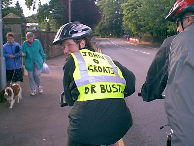 John O'Groats or Bust